“In a state one-fifth the size of the U.S. with less than 10,000 miles of road, flying is a way of life. Air taxis are to Alaska what yellow cabs are to New York and water taxis are to Venice. Scenic flights in a small plane or helicopter bring you face to face with Alaska’s natural beauty. ‘Fly an hour or walk a week’ is never more true than when, minutes out of town, you soar above the massive buttresses of Mt. McKinley or glide over iceberg-choked waters of Columbia Glacier. Some small planes are equipped with floats to land on mountain lakes, remote rivers or ocean bays. Others deploy skis to land on snowy glaciers.”
Flightseeing tour of Mt. McKinley on a clear day offers the most mind-boggling scenery in Alaska: a boulder-strewn labyrinth of treacherous crevasses seven miles long; a ten mile long phalanx of mile-high towers of black and brown granite, with ice below that is 3,700 feet deep and some more than 1,000 years old; on occasion the sun’s warmth releases immense blocks of ice that ricochets for a vertical mile before slamming into the glacier floor.
This map is excerpted from a brochure by one of the air travel companies that has offered flightseeing tours of Mt. McKinley for forty years, and shows the various guided tour air routes around the mountains and glaciers (400K, so slow download likely)
Logistics: Cirrus pilots can fly to Talkeetna (PATK), less than 45 minutes from Anchorage, and either sign up for a commercial air tour of McKinley or fly around its peaks on their own. A visit to the town of Talkeetna is also recommended. If you choose to flightsee near Mt. McKinley enroute to one of these airports, monitor CTAF on 122.7 or 122.725 for tour plane traffic and periodically announce your position, altitude and intentions in Denali National Park.
Consult the National Park Service’s flight page and the FAA’s Denali Flight Advisory page for maps and other important information.
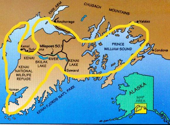
Self-guided flightseeing tour of the Kenai Peninsula offers Cirrus pilots a birds-eye view of the Kenai National Wildlife Refuge, Cook Inlet (including its volcanoes), Kenai Fjords National Park, Chugach State Park, Ellsworth Glacier and Prince William Sound. Plan on spending one to two hours flying, with stops as desired on paved runways in Kenai (PAEN), Soldotna (PASX), Homer (PAHO), Seward (PAWD), Valdez (PAVD) or Anchorage Merrill Field (PAMR). Take this trip in the morning, afternoon and/or evening (the sun doesn’t set until midnight or later in the summer) to experience the different lighting offered in the far north.
Logistics: Study the NACO Seward sectional chart and plan a clockwise or counter-clockwise route (non-stop or with a variety of stops) that includes the following appropriate diversions along a route that connects the following waypoints: Kenai VOR (ENA), Homer VOR (HOM), Seward airport (PAWD), Johnstone Point VOR (JOH), Valdez airport (PAVD), Whittier airport (PAWR), Anchorage Merrill Field (PAMR). The elevation of the Kenai Peninsula ranges from 2,000 to 3,000 foot msl flatlands in the western portion, to 6,500 to 7,000 msl peaks in the eastern, glaciered portion; north of Valdez there are 10,000 to 13,500 foot msl peaks of the Columbia Glacier and the Chugach Mountains. Plan your VFR altitude accordingly, and be aware of the restriction of flying below the designated minimum altitude over national parks and refuge areas. This map suggests an approximate route of flight: