Practical Tips for Icing
With the TKS system now in the middle of its second season of winter service in the Cirrus fleet, I thought it might be useful for us to share information and opinions on its use. The following notes are my personal views, based on various experiences and pre-flight planning techniques. Let me incorporate and invoke the usual Radomsky caveats here, since none of this stuff is to be found in, or condoned by, the POH or FARs.
Pre-Flight Planning
- Don’t take off in the winter without a thorough understanding of where the freezing level, cloud bases and cloud tops are located along your route of flight. I start the analysis by looking at the ADDS interactive TAFs page for both my departure and destination airport: it will show cloud bases and whether snow or freezing rain conditions are forecast. I will cancel the flight if there’s a winter storm forecast anywhere along the route of flight, since the TKS system is not certified or equipped for this condition. Of course, freezing rain is another taboo for flying (even with a certified system).
- Enroute weather: I then look at the ADDS icing forecast page to see the probabilities of icing along the route of flight at various altitudes. It also shows the cloud bases and tops, although this information can be too general for specific tactics. I then do a Skew-T analysis, especially for locations along the route of flight where the icing forecast shows a probability of cie.
- Skew-T analysis: this is the most important tool which I use for various times both before, during and after the proposed flight time to make a go/no go decision and to choose the optimal cruise altitude. Scott D. often gave tutorials and analysis in his posts, so those of you who don’t know anything about this subject might start by searching the archives, or by attending his seminar. Or you can go to the WEATHER PREDICTION EDUCATION website and start with lesson 291.
- For the somewhat initiated, here are a series of sample Skew-Ts with a layman’s explanation of how to read them for winter weather clues:
Let’s say that you’re thinking of flying from White Plains, NY (KHPN) to Bangor, Maine (KBGR) tomorrow morning. So you go to the Plymouth Skew-T homepage. It will show the following:
Enter 4-digit ICAO Station ID (e.g. KCON) or Lat,Lon (43.68,-73.88), then select model, type of product, forecast time, latest or previous model run, whether you want lifted parcel temperatures plotted or not, and size of diagram.
Type in KHPN in the ID/LatLon box on the left, and select the forecast timeframe from the Time box. Leave the other choices alone.
The site will then produce a Skew-T forecast (shown below) at HPN for 12Z (7 am eastern time) on Friday, January 14. The red line is temperature and the dotted black line is dewpoint. The temperature scale starts on the bottom (in Celsius), with gray lines slanting up to the right. The altitude scale is to the left, in both millibars and meters (multiply by three for a rough approximation of feet, since a meter is 39 inches). I’d also do a Skew-T plot for 27 and 30 hours, to cover my return flight.
To find the freezing level at this departure airport, follow the gray zero degrees temperature line, and note that it intersects with the red temperature plot at roughly 3,000 meters, or approximately 9,000 feet. To find the cloud base, note that the dashed black line (dewpoint) and red line (temperature) are close together starting just above the surface (298 meters, or 900 feet), and stay within a few degrees of each other until 3,633 meters (almost 12,000 feet): as we all know, when the temperature/dewpoint spread is close together there will be visible moisture, or clouds. But note that these clouds are to the right of the zero degree temperature line until roughly 9,000 feet, so a flight at, say 5,000 to 7,000 feet, will be clear of any potential ice.

Let’s say the route of flight is through the Boston area, so pull a Skew-T plot for KBOS. It shows the freezing level at 3,341 meters, or roughly 12,000 feet. It also shows a decent divergence between dewpoint and temperature starting at 743 meters (roughly 2,200 feet), so anywhere above that level would be above the cloud layer. Note the wind barb scale on the far right: expect 70 knot winds from the southwest.

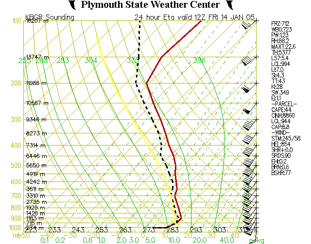
Now pull a Skew-T plot for Bangor (KBGR). It too shows a high freezing level (3,310 meters, or 10,000 feet), and cloud tops around 1,426 meters. So a flight below 9,000 feet will not encounter any ice, or much clouds, enroute. But it will be IFR all the way.
Just by way of comparison, since the above plots don’t show icing, here’s a plot for tomorrow at Buffalo (KBUF), also for 7 am EST. The temperature and dewpoint are to the left of the zero degree line, so any clouds will be below the freezing level. But note that the dewpoint and temperature lines intersect only briefly at the 1,223 meter height: so expect a thin cloud layer on descent (around 3,500 feet) and nothing more.

For another comparison, here’s a plot for tomorrow morning at Chicago Midway (KMDW). Like Buffalo, it is also totally in the freezing zone, but again there’s just a small cloud layer just near the surface.

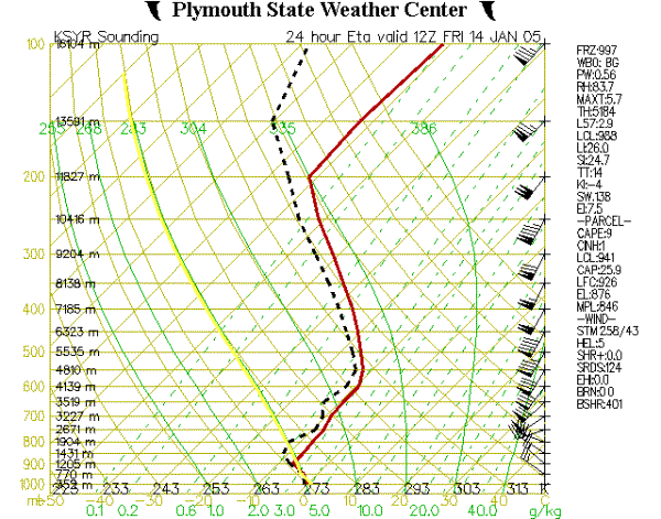
Where does one find some real ice conditions? Look at tomorrow’s plot for Syracuse, New York (KSYR). The cloud layer starts just above the surface and goes up to 1,205 meters (3,500 feet) and then the temperature/dewpoint spread stays uncomfortably close past 5,535 meters (16,000 feet). I’d tread very carefully in this area, since the forecast isn’t perfect and this plot indicates that there may well be clouds (and ice) all the way up to a very high altitude.
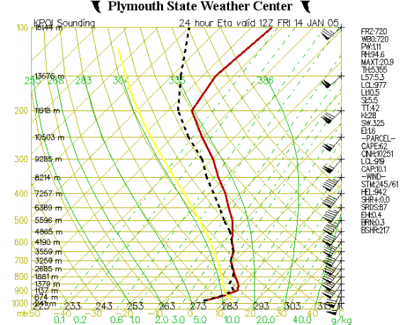
Finally, and even better yet, look at tomorrow’s Skew-T plot for Presque Isle, Maine (KPQI). This shows that there will be a small clear layer between the clouds from 1,137 meters to 1,881 meters: everything above and below that will be solid IMC. And above 2,685 meters (just below 6,000 feet) its all to the left of the zero degree line, so it will be solid icing conditions from there all the way up to 4,865 meters (nearly 15,000 feet).
In-Flight Tactics
1. Before taking off in the winter, I always top-off the TKS tank since it has a tendency to drip off the wings even if the pump isn’t on. I also carry at least three gallons of TKS fluid in the baggage compartment, for refills during the day.
2. I always turn on pitot heat prior to takeoff, even if there is no ice or clouds in the forecast. This way I have one less thing to worry about in-flight. Also, even when flying below a cloud layer there can be a decent amount of frozen moisture in the air that is only visible with the strobes on at night. So I keep the pitot heat on all the time and don’t have to worry about bad airspeed readings.
3. If on departure I’ll be climbing through a cloud layer, I turn on the TKS on the ground so that the wings, prop and windshield are nicely coated by takeoff. I don’t wait to be in the clouds to find out that ice has already accumulated.
4. Once at cruise altitude and power settings, I note the indicated airspeed (usually around 150 KIAS). This is, in fact the best indicator of icing, even before anything is visible on the windshield or the wings. If KIAS drops by 5-10 knots in smooth, level flight then ice is already building up and its time to take evasive action: immediately turn on the windshield heat all the way, pull out the red alternate air knob, and turn on the TKS pump. Depending on the circumstances, I’ll go to max pump for three minutes just to get the fluid flowing faster. Once it’s flowing, however, there’s no reason to keep it at max, since that would significantly reduce the available reserve. I’ll also immediately request a climb or descent from ATC, knowing from the pre-flight analysis where the tops and bases should be. If they’re not where I expected them, then its time to land or turn around. In the climb, I don’t let the airspeed drop below 100 KIAS, for two reasons: I don’t want to come anywhere near the heightened stall speed due to ice that may have already accumulated: and I don’t want a high deck angle which would expose too much of the bottom of the wings and tail to ice accumulation.
5. On descent, if there’s a cloud layer on the way down, I’ll turn on the TKS pump and alternate air before reaching the cloud layer. This way I’ll have one less thing to worry about even if its raining on the ground.
6. When I first turn on the TKS pump, I start the Count Up timer on the transponder. I use this to record my fluid usage, stopping and then starting it each time I use the TKS pump. If I find that I’ve used more than a total of 20 minutes of fluid before the approach begins, then its time to land and refill the TKS tank (unless I’m certain that the rest of the route is above the freezing level). This method produces is a rough guide on the fluid remaining in the tank, given a few minutes of max pump and the inevitable leakage after the system has been turned off. My reasoning is that I’d want to have a guaranteed 30 minutes of TKS fluid before an approach, in case I need to go missed and climb back up through a cloud layer enroute to an alternate.
7. Don’t be surprised if the surfaces which are not protected by TKS (e.g., wing roots and tips, spinner nose, vertical portion of the tail, wheel struts and steps) accumulate half an inch or more during only a few minutes of an icing encounter. In cruise flight, this will decrease airspeed by 5-10 knots and may ultimately sublimate away. In descent, this accumulation is to be expected, soI invariably plan on a no-flaps landing at 90 knots or better with power on all the way down to the flare.
8. Sometimes a clear layer of ice will form on the wings and the TKS won’t be able to get all of it off by the time descent begins. In fact, this layer can clog the stall warning port (a very small hole on the right wing): as a result, you’ll hear the horn blaring away continuously during climb or descent. All the more reason to plan the descent at a three degree standard rate and then a no-flaps, 90 knot landing.
Ice on the horizontal
tail surfaces, together with extended flaps, can cause a tail stall. I recall
reading about this in a recent issue of AOPA Pilot and in the CPPP weather
course. My understanding is that this condition requires the opposite inputs
for recovery than a normal wing stall. This is not a condition which can be
simulated in normal flight, so its not taught (of course I don't mean to
reignite the debate on full stalls).
Since its not easy to see ice on the tail, I think its safer to just assume its
there and land with precautionary measures (e.g., no flaps, higher approach
speed, long runway).
I recently had the isolated experience where for some reason the TKS did not
flow properly to one side of the elevator: the other side, and both wings, were
totally clean. The result was that one side accumulated a decent layer of ice
on the leading edge which did not dissipate before landing (in VMC,
incidentally). The plane still had all the normal control responses, but I kept
the approach and landing speeds high to avoid any problems.
Again, this is a tactic which builds in a margin of safety, just in case: I
don't want to test the stall characteristics of a plane with some ice
(especially asymetric) until its 10-12 inches above a nice long runway.