Practical Tips for Thunderstorms
With winter weather beginning to recede, so is the risk of encountering icing during a cross-country flight in Cirrus
But now its time to think about thunderstorms, which is the other bane of every pilot’s existence when it comes to significant weather threats. Many Cirrus pilots have Stormscope and WxWorx products in their planes, which provide virtually real time information on thunderstorm activity while enroute. But that’s only half the picture, because it is not prudent to begin a flight without a comprehensive understanding of what the forecast calls for. The following memo reflects my personal views, based on various experiences and pre-flight planning techniques. Let me incorporate and invoke the usual Radomsky caveats here, since none of this stuff is to be found in, or condoned by, the POH or FARs.
Pre-Flight Planning
- Don’t take off on a day when there’s potential for thunderstorms without a thorough understanding of the geographic area where that activity is located, the altitude ranges in which convective activity might be present, and the expected severity of the convective activity. I start the analysis by looking at a prog chart, such as the AOPA Surface Analysis Chart. It shows the weather fronts and systems over a 12, 24, 36, 48, 72, 96 and 120 hour basis. It also contains easy to read legend keys: thunderstorms, for example, are denoted in red. This gives the big picture view of storm activity that may be encountered enroute.
- Pilots might also find it useful to use the ADDS Flight Path tool, but I find that it loads slowly even with a broadband connection and doesn’t show me anything that isn’t already available by looking at the other ADDS tools.
- Instead, I look at the ADDS interactive TAFs page for both my departure and destination airport: it will show cloud bases and whether thunderstorm activity (the dreaded “TSRA” abbreviation) is forecast. I generally will not cancel a flight just because there is thunderstorm activity in the forecast, but I will carefully examine the weather enroute and plan several alternate airports in case there is a need to change course or go back instead of traversing a storm. Keep in mind that unlike some icing situations, the Cirrus cannot climb above major convective activity. But as a start, a cruising altitude of 10-13,000 feet will put you above alot of less-than-severe thunderstorm activity, and provide decent to excellent visibility (during the day) of what to avoid.
- Enroute weather: I choose a variety of enroute TAF sites and use those identifiers to study the Skew-T analysis for the entire route, looking at various times before, during and after the proposed flight time. This gives me an idea of where the location and potential intensity/probability of the thunderstorm activity might lie
- Skew-T analysis: this is the most important tool which I use for various times both before, during and after the proposed flight time to make a go/no go decision and to choose the optimal cruise altitude. Scott D. often gave tutorials and analysis in his posts, so those of you who don’t know anything about this subject might start by searching the archives, or by attending his seminar. Or you can go to the WEATHER PREDICTION EDUCATION website and start with lesson 291.
- For the somewhat initiated, this memo displays a series of sample Skew-Ts with a layman’s explanation of how to read them for thunderstorm clues:
Let’s say that you’re thinking of flying from White Plains, NY (KHPN) to Nashville, Tennessee (KBNA) tomorrow morning.
So you go to your favorite prog chart and see something like this:

It shows a significant area of thunderstorm activity (the red threat) over Mississippi, Alabama and parts of Arkansas and Tennessee, as of the early morning (6:00 am Central time).
The next chart in the sequence confirms that this early-morning thunderstorm is no fluke, and will be blanketing the area all day:

It shows the storm smack over nearly all of Tennessee as of 6:00 pm, meaning that the storm is going to be lingering around the destination airport virtually all day. The only good news thus far is that its heading east, rather than northeast, so it won’t be an issue for the return flight to New York.
So next you go to the Plymouth Skew-T homepage. It will show the following:
Enter 4-digit ICAO Station ID (e.g. KCON) or Lat,Lon (43.68,-73.88), then select model, type of product, forecast time, latest or previous model run, whether you want lifted parcel temperatures plotted or not, and size of diagram.
Type in KHPN in the ID/LatLon box on the left, and select the forecast timeframe from the Time box. Leave the other choices alone.
The site will then produce a Skew-T forecast (shown below) at HPN for 15Z (10 am eastern time) on Tuesday, March 22. The red line is temperature and the dotted black line is dewpoint. The temperature scale starts on the bottom (in Celsius), with gray lines slanting up to the right. The altitude scale is to the left, in both millibars and meters (multiply by three for a rough approximation of feet, since a meter is 39 inches). I’d also do a Skew-T plot for 27 and 30 hours, to cover my return flight.
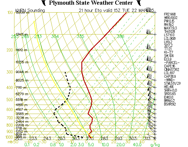
The significant graphic element in looking for thunderstorm activity is the yellow line, which represents the theoretical parcel lapse rate (e.g., the change in temperature/stability of a theoretical box of air as it is lifted up through the atmosphere). Go read a textbook on weather if you want a fuller explanation, but for laymen the thing to watch out for is when the yellow line intersects, or is to the right of, the red temperature line. That’s not the case in the chart just above, so this is a classic example of a sunny day, withy nary a cloud in the sky (since the dewpoint and temperature lines don’t intersect either).
But the Skew-T for Memphis, Tennessee (west of our destination on tomorrow’s theoretical flight) tells a very different story:

You’ll immediately notice that there is a significant gap between the red temperature line and the yellow parcel lapse rate line to its right, and it extends from 1,183 meters (roughly 3,000 feet) all the way up to more than 9,142 meters (28,000 feet). So, yes, thunderstorms are forecast for the area at 21Z (4 pm), and up to heights that cannot be climbed over in Cirrus. But to really understand how strong this convective activity might be, and whether it has a strong probability of occurring, consider the seemingly gibberish numbers to the right of the graph: Items like LI, SI, KI, CAPE and its neighbor CINH are stability indices which together answer those questions.
LI (Lifted Index) is the lifted index at 500 millibars (roughly 15,000 feet). In technical terms, its the difference between the actual and parcel temperature at that atltitude. Less than zero means the possibility of thunderstorms, while –4 or below means severe thunderstorms. In this case the lifted index is –7.3, which means serious convective activity will exist (if it actually happens).
SI (Showalter Index) is the same thing as LI, but at 850 millibars (roughly 5,000 feet). More than +3 indicates showers and thunderstorms; zero indicates showers; and –3 or below indicates severe convective activity. In this case the SI is –0.7, which again confirms serious convective activity at this lower altitude (if it actually happens).
Incidentally, if both the LI and SI are negative, then the atmosphere from 15,000 feet and down is highly unstable; conversely, if both are positive, then the atmosphere is quite stable. However, if the LI is negative but the SI is positive, then the boundary layer is unstable and some capping exists: so the thunderstorm activity will not be of the towering variety.
KI is the K-Index, which is a more sophisticated index than LI or SI because it assesses convective potential by measuring the temperature and dewpoint spreads at both 500 and 850 millibars. It is, in a way, a combination of the LI and SI indicies. KI of 15-25 means small potential for convective activity; 26-39 means moderate potential; while more than 40 means a high chance of convective activity. In this case the KI is 24, which is right on the borderline of real, potential convective activity.
CAPE (Convective Available Potential Energy) is a very powerful index, because it shows the potential energy for convective activity stored in the atmosphere by measuring the area between the temperature curve (the red line) and the parcel laps rate curve (the yellow line). Essentially, it adds up the LI (lifted index) for all altitudes, not just at 500 millibars. A CAPE value of less than 1,000 means weak convective activity; 1,000 to 2,500 is moderate activity; and greater than 2,500 means strong convective activity. In this case the CAPE is 1,958, which means that tomorrow’s convective potential is worthy of a pilot’s respect. But at that level, it does not presage strong convective activity.
Finally, CINH (Convective Inhibition) measures convective inhibition: how likely it is that a thunderstorm will develop. It computes the amount of energy that the lifting mechanism must expend to overcome the cap on unchecked convective activity. Essentially, it tells whether there is enough CAPE to unleash extensive convective activity. CINH of more than 200 means the cap is quite strong, so its highly unlikely that thunderstorms can develop. Between 50 and 15 means that strong lines of clouds will develop; between 15-50 means that some strong thunderstorms are likely; and less than 15 means fair weather cumulus clouds. In this case, CINH is 6, which is not very threatening.
The bottom line analysis of the graph above is that thunderstorms are likely, but not towering. So from a decent altitude (10-13,000 feet), it may well be possible to stay above most activity and to veer clear of anything that is particularly tall and threatening.
By comparison, look at the Skew-T for Nashville at 18Z (1 pm eastern time), right around the expected arrival time:

None of the five key indicies
(LI, SI, KI, CAPE and CINH) have interesting values: in particular, there just isn’t enough CAPE to light a
firecracker. And the graph confirms
this at a glance: the yellow line never
really crosses to the right of the red line.
The only interesting thing to note from this is that the cloud layer
will extend virtually from the surface to 15,000 feet or higher, with the
freezing level at 2,733 meters (roughly 8,500 feet). So icing is still a consideration, even with thunderstorms not
very far away at Memphis.
In-Flight Tactics
1. I prefer to flip between Stormscope and Traffic Watch on the #2 Garmin, with the Stormscope set at 120 degree view and 50 miles. I also prefer to fly at 10-13,000 feet even if there is a speed penalty due to the wind, because it generally offers a better view of the weather and sometimes even puts me above the system (remember to check the LI, SI and CINH indexes to see if this is feasible).
2. When the MFD warns of lightening, I clear all of the details and set it for 200 miles: this provides a large scale view of where the thunderstorm activity is located, and the direction in which it’s traveling. Periodically I hit Clear Strikes on the MFD, so that I can see where the storm is moving in relation to my proposed flight path.
3. I also watch the Garmin #2 and stay clear of any cells/strikes within 20 miles. I also watch the strike rate in the upper right and corner of the Stormscope display on the Garmin: it shows the number of strikes within the displayed radius (e.g., 25 or 50 miles) within the past minute. ATC is very accommodating on days such as this, permitting deviations of 10-30 degrees as requested.
4. More often than not, simply staying the course and flying the original flight path is the best alternative. Remember, a Cirrus is traveling at more than 150 knots, while the storm is moving at 30-50 knots, so its usually possible to outrun a storm, especially if the strike rate is rather low. This is true even when it appears on the MFD (200 mile range) that there is dangerous activity all around.
5. At times when it is not possible to find a wide path between the cells and strikes shown on the Stormscope, or when the strike rate within 50 miles goes above 20-40, consider asking ATC for a hold or diverting to an alternate airport until the weather passes.
6. Nighttime convective activity is a whole other story, which I won’t venture to explore in this memo. The short answer, however, is DON’T.