What Icing Looks Like
Ilan Reich
March 2, 2006
With the recent spate of accidents due to icing, I thought it was worth revisiting the subject of how to make intelligent go/no go decisions.
I
had an Angel Flight scheduled for this morning, from northern Vermont to
eastern Long Island, then returning to White Plains, NY.
I
started my flight review two days ago, at which time the forecasters were
already calling for snow today. I
checked each locality on www.weather.com,
and found that only New York City was slated to actually get snow. I then looked at the Skew-T plots (my
favorite site is Plymouth
State Weather Center, available through the COPA weather page) for three
locations: KBTV (Burlington, VT), KHTO
(East Hampton, NY), and KHPN (White Plains, NY) for a variety of time slots on
Thursday. These showed no significant
weather all the way through the 48 hour forecast, so I kept my fingers crossed
that I could complete the mission and still return to NYC before the snow storm
arrived.
By
yesterday morning, the picture had changed:
although the Skew-T plots continued to show no significant weather in
Vermont or eastern Long Island, the NY City area was now showing a “wall of
icing” (discussed below) starting after 1 pm and continuing through the
night. Which meant that I would be
cutting it very close to the wire if I began the mission at 8 am and hoped to
return back to New York City (around noon) before the storm. Based on that data, I saw a 50/50 chance
that I would be stuck on eastern Long Island for the duration of the storm,
with lots of time to contemplate why I had chosen to begin a three-legged
mission that could not be realistically finished.
I
don’t care for 50/50 odds when flying, so I decided to cancel the Angel Flight
mission. I also considered the fact
that it was unlikely that the pilot with the other half of the mission was
going to be able to fly in that weather, so there was no point in leaving the
patient stranded far from home.
Instead, I decided to go flying locally, to practice instrument
approaches with an instructor.
Later
that day, as the TAFs were revised, it was clear that the arrival time of the
storm was moving up: rather than 1 pm,
HPN was calling for light snow by 10 am.
Based on that information, I scrapped the training flight as well.
This morning, I went back to look at how accurate the forecasts were. Its just after 10 am as I write this, and it is definitely snowing outside; and the TAFs for the various locations confirm the data in the Skew-Ts from one and two days ago (KISP is Islip, roughly 50 miles west of East Hampton and the nearest locale with a TAF):
Burlington weather is
still VFR, with no snow activity until late tonight:
KBTV 021134Z 021212 18008KT P6SM SCT050 SCT250
TEMPO 1214 BKN050 FM1700 VRB03KT P6SM SCT045 BKN250 FM2100 36008KT P6SM OVC040 TEMPO 0206 1SM -SHSN BR BKN020 FM0600 34015G22KT P6SM BKN040
White
Plains weather is snow, snow, snow: all
day and into the night. While the
airport might officially be just at or above the ILS minimums, for all
practical purposes it will be closed for single engine GA operations:
KHPN 021415Z 021412 01005KT 1SM -SN BR OVC010
TEMPO 1417 1/2SM -SN FG VV002 FM1700 06011KT 1SM -SN BR OVC004 FM1900 06014KT 1/2SM -SN FG VV002 FM2200 02012G22KT 2SM -SN BR OVC004 FM0200 34012G22KT 2SM -SN BKN007 OVC015 FM0600 32013G21KT P6SM SCT015 BKN060 OVC100 Islip has already begun to get snow, so the storm moved in earlier than originally forecast; this confirms the decision to not cut it close to the wire:
KISP 021431Z 00000KT 2 1/2SM -SN OVC013 M01/M06 A2972 RMK AO2 P0000
KISP 021144Z 021212 VRB03KT P6SM SCT070 BKN100
FM1500 09005KT P6SM -SN OVC050 FM1800 08007KT 2SM -SN BR OVC007 FM2000 06010KT 1SM -SNPL BR OVC004 FM2200 02010G20KT 2SM -SN BR OVC004 FM0300 36012G22KT 4SM -SN BKN009 OVC015 FM0600 32013G21KT P6SM SCT015 BKN060 OVC100And, finally, the East Hampton METAR shows it as being below minimums for the GPS approaches: KHTO 021438Z 00000KT 3SM -SN OVC050 01/M07 A2974
Now to discuss how the use of Skew-Ts are vital to understanding winter weather conditions.
For
the uninitiated, the red line is temperature; the black dotted line is dew
point. If they get real close to each
other (or meet up), there will be clouds.
If that intersection occurs to the left of the pale green,
rightward-tilting line emanating from zero on the bottom scale, then its
indicative of clouds with high likelihood of icing (unless its to the left of
the –20 Celsius line). Altitude is
shown in meters in the black letters on the left (millibars are to the far
left, for those who want to correlate this data with the relative
humidity products at various altitudes).
First, the Burlington, VT
Skew-T at 7 am this morning:
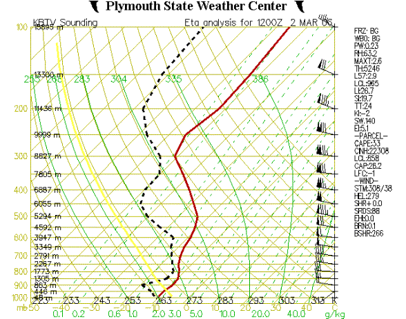
This plot shows a chance of clouds at 1,773 meters (not coincidentally, very similar to the scattered clouds at 5,000 feet shown in the TAF above). But at all other altitudes there are is no visible precipitation.
Next
is the 10 am Skew-T for East Hampton:

From
1,367 meters to 4,04 meters (roughly 4,000 to 7,000 feet) the dew point and
temperature lines intersect, and that range is to the left of the zero degree
Celsius base plot: so one should expect
3,000 feet of icing conditions. Pretty
much just at the margin of “safe” (but not legal) flight in an SR22 with
TKS.
Below
1,367 meters, the East Hampton plot is showing no clouds. So in theory there would not be a problem
doing this approach once the plane was beneath the clouds (and certain icing). Note, however, that the METAR above tells a
different story as to actual conditions:
500 foot overcast ceiling, which is below minimus. So the bad weather ended up moved in faster
than the Skew-T model had predicted three hours ago.
And
now for White Plains Skew-T:
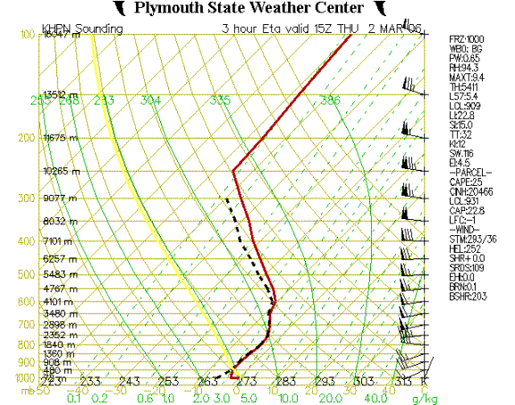
Ugly is the only word to describe this. The overlapping red and dotted black lines indicates solid icing from 480 meters (1,200 feet) to 4,101 meters (over 12,000 feet). There is no way that this condition is even remotely “safe” for an SR22. It is literally a wall of icing that is best appreciated from the warmth of one’s home or in a turbine engine aircraft with two pilots who do this sort of flying for a living.
In
sum, there is a wealth of weather products available online (and very easily
through the COPA weather
links page). IMHO,
the Skew-T plots can provide the incredibly valuable information on where and
when to expect clouds and icing in the winter.