Section Four: Getting Back TO THE u.s. FROM ALASKA
Its a Long Trip Going Home, So Take a Different Route
- Flying back to the continental U.S. from Alaska is not a short journey. The best advice is to take a different route on the way home than the route that was traveled on the way to Alaska. Central/east coast pilots should also consider visiting a national park on the way home so as to break up the journey and make the return trip more interesting. For example, rather than flying via the inland route back through Whitehorse, Yukon, consider taking flying the coastal route from Anchorage to Sitka, Alaska then onward to Seattle or Vancouver area; with a stop at Yellowstone or Glacier National Parks, or Mount Rushmore, or Duluth (especially if its migration time) on the way back home.
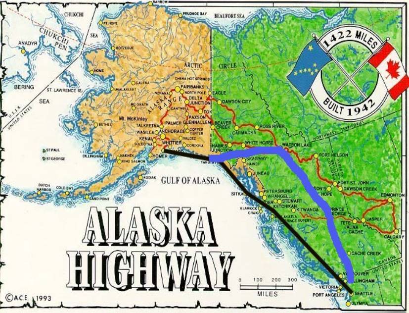
- There is so much beautiful terrain to see in Alaska and northwestern Canada (Yukon and British Columbia). This makes for a variety of alternatives for the return flight to the continental U.S. The three recommended choices are: the coastal route (shown in black on the map below), the inland route along the Alaska Highway (shown in red on the map below), or a combination of the coastal route to Yakutat and then inland to fly the Trench (shown in black and then blue on the map below). The first choice can be flown in one day; the other two will take two days or more in a Cirrus.
- The FAA website offers an overview on flying in Alaska and specific tips for various towns and regions of Alaska.
.
Route One:
Flying the Coastal Route (print this route)
· Once again, the coastal route is the only route from Alaska that bypasses a landing in Canada. This may be a benefit for pilots or passengers with immigration issues getting back into the US from Canada. Pilots considering this route for immigration reasons should be aware that IFR conditions can frequently exist at Sitka (the recommended refueling stop), due to the coastal fog and rainforest conditions which often arise in that part of the state.
· Unlike the coastal route from the continental US (Route Two in Section Two), the return route to the continental US offers a number of alternate airports inside Alaska. Nevertheless, if the coastal route is being flown for immigration reasons, it is advisable for the pilot to have an instrument rating and to be prepared for IFR conditions both in southern Alaska as well as in Washington state. And, be advised that ATC cannot provide any radar coverage for enroute or approach segments (since there are virtually no radar facilities in Alaska other than the Anchorage area), so you’re entirely on your own. As noted in Section Two, even experienced pilots would say that flying an instrument approach into airports like Ketchikan, Sitka and Juneau can be as hard core IFR as it gets, and IFR conditions can often be the rule, rather than the exception, at those coastal airports.
· On the other hand, when VFR conditions exist, flying this route along the coastline of southern Alaska and British Columbia offers magnificent views of mountains, glaciers, forests, inlets and the ocean.
· The first leg of this route is from the Anchorage area to Sitka (PASI), a distance of approximately 540 nm. Significant mountainous terrain exists over the Kenai peninsula and just inland from the coast, so the recommended IFR route with the highest MEA of 10,000 feet would be along the Victor airways: V320 to Johnstone Point VOR (JOH), V319 to Yakutat VOR (YAK), V440 to SALIS intersection, and then direct to Sitka airport (PASI). Interesting places to visit or refuel along the way include Valdez (PAVD), Juneau (PAJN) and Yakutat (PAYA); see Section Three for details. The port town of Valdez is the southern terminus of the Trans Alaska Pipeline, and Juneau is the capital of Alaska
· The second leg of this route would be from Sitka to the Seattle area (e.g., Boeing Field (KBFI)), a distance of approximately 760 nm. Significant mountainous terrain exists just inland from the coast, so the recommended IFR route with the highest MEA of 8,000 feet would be along the Victor airways: V311 to Annette Island VOR (ANN), V309 to Prince Rupert NDB (PR), A10 to Bella Bella VOR (YJQ), V347 to Port Hardy VOR (YZT), V440 past Comox VOR (QQ) to Victoria VOR (YYJ), then V495 to Boeing Field (KBFI). There is usually a tailwind along this route; if there isn’t then a stopover in Ketchikan (PAKT) or an airport in Canada such as Prince Rupert (CYPR) (if there are no immigration issues) would be advisable. There is no radar coverage after Anchorage until roughly 75 nm northwest of Vancouver, although there is excellent radio communication with ATC.
· If flying IFR, use the NACO L-1 enroute chart. If flying VFR, use the following NOAA sectional charts: Anchorage, Juneau, Ketchikan; and the following Canadian sectional charts: Atlin, Kitmat and Vancouver.
· The scenery and terrain on the coastal route is quite spectacular, with incomparable views of glaciers between Anchorage and Yakutat (e.g., the Ellsworth Glacier on the Kenai Peninsula, the Bering and Malaspina Glaciers beginning roughly 100 nm before Yakutat, with 18,000 foot Mt. Elias in the distance), as well as the Prince William Sound. Between Yakutat and Sitka there are beautiful mountains and inlets, as well as the Brady Glacier. Between Sitka and Seattle there are also beautiful mountains, bays and inlets along the rugged coast of British Columbia, as well as Vancouver Island. If the coastal route is flown when VFR conditions exist, the MEAs would not be relevant and the pilot could simply track the coastline at a suitable VFR altitude.
· Listed below are directory information, diagrams and instrument approach procedures for each of the airports mentioned in Route One (or, in the case of a navigation aid, the associated airport). This information was obtained from either AOPA or NavCanada, is copyrighted, has an expiration date of mid-2004, and is presented for informational purposes only.
Bella Bella (CYJQ)
Juneau (PAJN)
Ketchikan (PAKT)
Port Hardy (CYZT)
Prince Rupert (CYPR)
Sitka (PASI)
Valdez (PAVD)
Victoria (CYYJ)
Yakutat (PAYA)
Route Two:
Flying the Inland Route along the Alaska Highway (print this
route)
· The inland route along the Alaska Highway is simply the reverse of a portion of route one, and all of routes four and five, which are described in Section Two. Significant mountainous terrain exists from Anchorage all the way to Fort Nelson, British Columbia (CYYE), so the recommended IFR route is along the published airways: the first leg is approximately 500 nm and departs the Anchorage/Kenai Peninsula area toward MATTA intersection, then fly V456 Gulkana VOR (GKN) or the adjacent Glennallen NDB (GLA), the G8 airway to BEFTI intersection and onward to Northway VOR (ORT) or the adjacent Nabesna NDB (AES), then V444 to Beaver Creek NDB (YXQ) , then A2 to Burwash NDB (DB), then direct to Whitehorse, Yukon (CYXY). The highest MEA along this route is 10,000 feet. The second leg on this recommended IFR route is approximately 395 nm, and the highest MEA is 9,000 feet: depart Whitehorse (CYXY) and fly A2 past Watson Lake VOR (YQH), and Liard River NDB (ZL), to Fort Nelson, British Columbia (CYYE). The third leg has no significant terrain, and can be flown from Fort Nelson, British Columbia (CYYE) direct to either Peace River VOR (YPE) or Fort St. John VOR (YXJ) and then direct to Edmonton City Centre airport (CYXD).
· If flying IFR, use the NACO L-1 enroute chart and the Canadian LO 5 and LO 1 enroute charts (1.5MB, expect slow download). If flying VFR, use the NOAA Anchorage and Whitehorse sectional charts, as well as the following Canadian sectional charts: Whitehorse, Atlin, Fort Nelson, Prince George and Edmonton. A large portion of this route can be flown using the Canadian sectional chart entitled Alaska Highway.
· Whether flown VFR or IFR, the trip from the Anchorage/Kenai Peninsula area to Edmonton is more than one days’ flying time for most pilots. So plan on an overnight stop in either Whitehorse, Watson Lake, or Fort Nelson and then another overnight stop in either Edmonton or Calgary.
· When VFR conditions prevail, consider flying visually along the Alaska Highway (rather than IFR) from the Anchorage/Kenai Peninsula area to Whitehorse, Yukon (CYXY), then to Fort Nelson, British Columbia (CYYE), then to Edmonton City Centre airport (CYXD). It affords a birds’ eye view of some of the magnificent valley, mountain ranges and glaciers that characterize this region. Depending on your comfort level, the height of the valley floor at a given point and the weather, you can fly at 3,500 or 5,500 feet for this entire route, or you can go higher and be near or at the tops of the mountains (generally below 7,500 feet) for the entire route.
1. The first leg goes from Anchorage to Gulkana (PAGK), a distance of approximately 140 nm. Depart Anchorage, following the highway at a heading of 19 degrees along the Cook Inlet as it heads toward Palmer (PAAQ); then fly at a heading of 49 degrees, following the highway over the Matanuska River and its valley to Sheep Mountain (PASP). Continue through the Tahneta Pass, which is 3,300 feet msl and is surrounded by 6-7,000 foot high mountains: this pass is actually an active fault that separates the Chugach Mountains and its glaciers to the south and the Talkeetna Mountains and its Dall sheep to the north, so be on the lookout for both snow and sheep. Beyond the Tahneta Pass is Eureka/Skelton (PAZK), which is the highest elevation aiport in Alaska (3,289 feet); AWOS available on 134.95. Continue on a 49 degree heading to Gulkana (PAGK): just before Gulkana airport catch a view of the Trans Alaska Pipeline as it passes north/south on its way to the new port town of Valdez (PAVD) (the original town was submerged and destroyed by the 1964 earthquake).
2. The second leg goes from Gulkana (PAGK) to Northway (PAOR), a distance of 276 nm. Two options are available: either fly direct to Northway (PAOR) at 7,500 feet over the Copper River Basin and the Alaska Range (37 degree heading for 110 nm); or follow the highway for 135 nm as it winds through the basin and mountains. This latter option departs Gulkana VOR (GKN) at a 360 degree heading and follows the highway through the Copper River Basis past Duffy’s Tavern (PADT), then through the Mentasta Pass (2,400 feet high) to Tok Junction (6K8) through the 6,000 foot high mountains of the Alaska Range, then at a heading of 100 degrees to Northway (PAOR) across the broad wetlands of the Tanana River. Northway airport has a 3,300 foot gravel runway, with fuel, food and US customs. The runway was once 5,100 feet long until a recent earthquake shortened it and left it in a decrepit state.
3. The third leg goes from Northway (PAOR) to Beaver Creek (CYXQ), to Haines Junction (CYHT), to Whitehorse (CYXY), a distance of 254 nm. Depart Northway VOR (ORT) on the 70 degree radial and you will pick up the highway about five miles past Northway airport (PAOR) as it traverses the broad wetlands of the Tanana and Chisana Rivers. Follow the highway at a 110 degree heading to Beaver Creek (CYXQ). The Alaska/Yukon border is ten miles before Beaver Creek. Proceed through the wide Shakwak Trench to Burwash NDB (DB), which is at the northwestern tip of Kluane Lake (the largest in the Yukon and is notorious for high winds, so check the weather first). Follow the highway at a 110 degree heading along the edge of the lake to Haines Junction (CYHT). From there continue following the highway at a 66 degree heading to Whitehorse, Yukon (CYXY), first parallel to the Dezadeash River and then along the wide valley of the Takhini River. In the distance to the south and west are towering 14,000 to 18,000 foot high mountain peaks and the immense ice fields of the Kaskawulsh, Hubbard, Seward, Malaspina, Logan and Columbus Glaciers. If weather and time permit, it is worth considering a diversion to fly over any portion of these forbidding and breathtaking sights.
· Listed below are directory information, diagrams and instrument approach procedures for each of the airports mentioned in Route Two (or, in the case of a navigation aid, the associated airport). This information was obtained from either AOPA or NavCanada, is copyrighted, has an expiration date of mid-2004, and is presented for informational purposes only.
Beaver Creek (CYXQ)
Burwash (CYDB)
Calgary (CYYC)
Edmonton City Centre (CYXD)
Eureka/Skelton (PAZK)
Fort Nelson (CYYE)
Fort St. John (CYXJ)
Gulkana (PAGK)
Haines Junction (CYHT)
Northway (PAOR)
Palmer (PAAQ)
Peace River (CYPE)
Sheep Mountain (PASP)
Tok Junction (6K8)
Valdez (PAVD)
Watson Lake (CYQH)
Whitehorse (CYXY)
Route Three: Flying the Combination Coastal Route and Inland Route through the Trench (print this route)
· This route combines the beauty of the Alaska coastline (e.g., Prince William Sound and the glaciers beginning roughly 100 nm before Yakutat) with the inland flying experience over the rugged isolation of the Trench (which is basically a natural ditch through the Rocky Mountains). As such, it is the reverse of a portion of routes two and three described in Section Two. Some pilots consider this to be “as good as it gets” for scenic beauty and variety on a VFR day. Note, however, that there is hardly a shred of civilization in sight for most of this route, so it should not be attempted on a marginal VFR day (unless the pilot is ready and able to switch to IFR) and should not be flown without maintaining radio contact with at least one buddy airplane. It is advisable to plan on spending two days flying this route, with refueling and/or overnight stops at either Yakutat, Whitehorse, Watson Lake, or Prince George.
· The first leg goes from the Anchorage area to either Whitehorse, Yukon (CYXY), a distance of approximately 485 nm, or to Watson Lake, Yukon (CYQH), a distance of approximately 650 nm. The choice of destination is a function of wind direction/strength and the pilot’s preference for duration of flight. Significant mountainous terrain exists over the Kenai peninsula and just inland from the coast, so the recommended VFR route with the highest MEA of 9,500 feet would be along the Victor airways: A1 airway all the way to Yakutat VOR (YAK), starting with Campbell Lake NDB (CMQ), then ATYOL intersection, then ATAGA intersection, then Yakutat VOR (YAK). Yakutat airport (PAYA) has a 7,700 foot paved runway. From there, fly GPS direct to either Whitehorse (CYXY) or Watson Lake (CYQH).
· If flying IFR, use the NACO L-1 enroute chart. If flying VFR, use the NOAA Anchorage sectional chart and the Canadian Whitehorse sectional chart.
· The scenery and terrain on the coastal portion of this route is quite spectacular, with incomparable views of glaciers between Anchorage and Yakutat (e.g., the Ellsworth Glacier on the Kenai Peninsula, the Bering and Malaspina Glaciers beginning roughly 100 nm before Yakutat, with 18,000 foot Mt. Elias in the distance), as well as the Prince William Sound. MEAs are not relevant on this portion of the route, since the pilot would be tracking the coastline at a suitable VFR altitude. After making the turn at Yakutat (YAK), the minimum safe MEA is 9,500 feet, as this route traverses the spectacular beauty of the Tweedsmuir Glacier and the Rocky Mountains. From that altitude one can safely climb if a switchover to an IFR flight plan becomes necessary.
· The second leg goes from either Whitehorse, Yukon (CYXY) or Watson Lake, Yukon (CYQH) to Prince George, British Columbia (CYXS), a distance of approximately 600 nm and 450 nm, respectively. The Trench begins after Watson Lake. If flying VFR, use the following Canadian sectional charts: Whitehorse, Atlin, Fort Nelson and Prince George.
· The recommended VFR route from Whitehorse, Yukon (CYXY) to Watson Lake (CYQH) is a distance of 195 nm, and is depicted with a trail of blue diamonds on the Canadian VFR charts for Whitehorse and Atlin. Depart Whitehorse airport and follow Schwatka Lake, then follow the highway eastbound toward Marsh Lake (not the branch heading south roughly 8 nm before Marsh Lake); then follow the highway along the edge of that lake and head eastbound again to follow the highway along the Little Atlin River (not the branch heading south along Little Atlin Lake); then follow the highway along the edge of Teslin Lake; at Teslin airport (CYZW) the highway separates from the lake and continues eastbound through the mountains to Watson Lake (CYQH). Note that just alongside Pine Lake airport (CFY5) the highway goes through a small pass at 3,300 feet msl (the surrounding mountains are 6,000 to 7,000 feet high). All of this all sounds much more complicated than it actually is: just look at the recommended blue diamond VFR route depicted on the Canadian sectional charts.
· The recommended VFR route from Watson Lake (CYQH) to Prince George (CYXS) is a distance of 340 nm. The Canadian VFR charts for Prince George and Fort Nelson depict the recommended route with a trail of blue diamonds: depart Watson Lake at a 110 degree heading, across the open tiaga terrain and the Liard River plain to the Kechika River. Follow that river (don’t veer to the left when it intersects the Gataga River), as it becomes the very small Fox River and then the larger Finlay River at Fort Ware (CAJ9); continue on this track over the entire 110 nm length of Williston Lake; then at MacKenzie (CYZY) follow the highway alongside McLeod Lake all the way to Prince George (CYXS). Note that between the end of the Kechika River and Fort Ware the Trench narrows and its floor rises to a 3,500 foot high pass through the surrounding high mountains (up to 10,000 feet); this is the choke point for weather. There is no way around the pass, so if its closed off due to weather, its time to turn around (aren’t you glad you left Watson Lake or Whitehorse with full tanks?). Again, this route sounds much more complicated than it actually is: just look at the recommended blue diamond VFR trail depicted on the Canadian sectional charts.
· The route from Watson Lake (CYQH) to Prince George (CYXS), which is through the Trench itself, has no radio facilities to talk with ATC except for an RCO on 126.7 at Fort Ware (CAJ9), with limited range due to the mountainous terrain. So don’t expect to receive many weather updates enroute. Also, there are no published airways for IFR navigation along this segment of the route through the Trench, and the typical area minimum altitude in this region is 12,000 feet high, so don’t expect a swift or safe transition to an IFR flight plan if the weather deteriorates.
· From Prince George (CYXS), one can fly to the Seattle/Vancouver area, Edmonton or Calgary, and from there proceed east or south back to the continental US. The Victor airway routes are quite straightforward, and the Canadian sectional charts depict several recommended routes to these areas. If flying IFR, use the Canadian LO 2 enroute chart (1.5MB, so expect slow download).
· Listed below are directory information, diagrams and instrument approach procedures for each of the airports mentioned in Route Three (or, in the case of a navigation aid, the associated airport). This information was obtained from either AOPA or NavCanada, is copyrighted, has an expiration date of mid-2004, and is presented for informational purposes only.
Calgary (CYYC)
Edmonton City Centre (CYXD)
Fort Ware (CAJ9)
Pine Lake (CFY5)
Prince George (CYXS)
Teslin (CYZW)
Watson Lake (CYQH)
Whitehorse (CYXY)
Yakutat (PAYA)
Home | Introduction | One: Flying in Canada | Two: Getting There
Three: Things to Do in Alaska | Four: Getting Back to the US from Alaska | Five: Equipment List
Six: Charts and Aeronautical Information | Photo Gallery: 2004